-

Emanuel Deutschmann
-

Ettore Recchi
Part-time Professor
Robert Schuman Centre for Advanced Studies

Read more
Blog, Migration Governance
The Controversial EU Concept of Integration
Integration is one of the major challenges posed to the European Union and it is even more so in light of the millions of refugees displaced by the war in Ukraine just in the...
A new global dataset on cross-border roads, paths, railroads, and ferries reveals that borders of very rich and very poor countries have ample cross-border traffic infrastructure, much more so than middle-income countries. Why is this the case? Our new study explores this counterintuitive pattern and potential explanations.
From border fortification to cross-border traffic infrastructure
Borders between countries play an important role in regulating the transnational mobility of people and commodities. Most research on the topic focusses on classifying borders in terms of fortification (walls, fences, green borders, etc.). In our Global Mobilities Project, we developed a different framework. Our approach considers cross-border transport infrastructure (paths, roads, railroads, and ferries)—together with political checkpoints at these border crossings— as measures of the permeability of borders worldwide: More and better transport infrastructure increases the permeability of a given border, while checkpoints provide the political capacity for reducing entries.
OpenStreetMap as a valuable data source
To turn this idea into a systematic measurement, we used automatized computational methods combined with extensive manual checks:
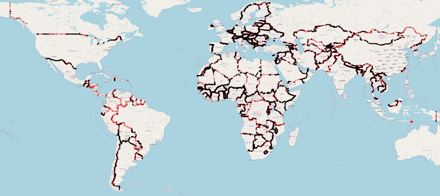
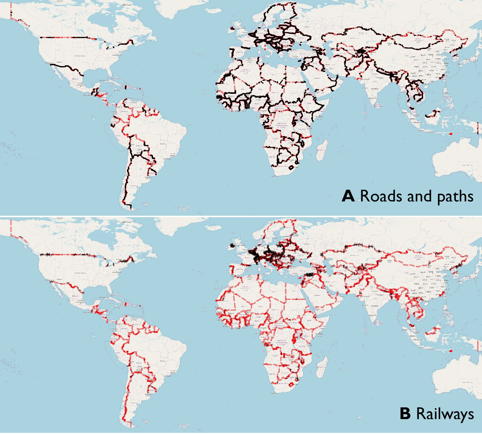
- To detect cross-border transport infrastructure and checkpoints, we parsed comprehensive data with global coverage from OpenStreetMap (Figure 1).
- Additional data from the World Food Programme and B’Tselem was used to complement the information on checkpoints.
- Based on this raw material, we constructed an index of border permeability for 312 land borders worldwide.
Figure 1. Cross-border road and railway infrastructure at land borders worldwide
Source: Deutschmann et al. 2023
What we learn from the permeability for 312 land borders worldwide:
Europe and Africa have the most permeable borders
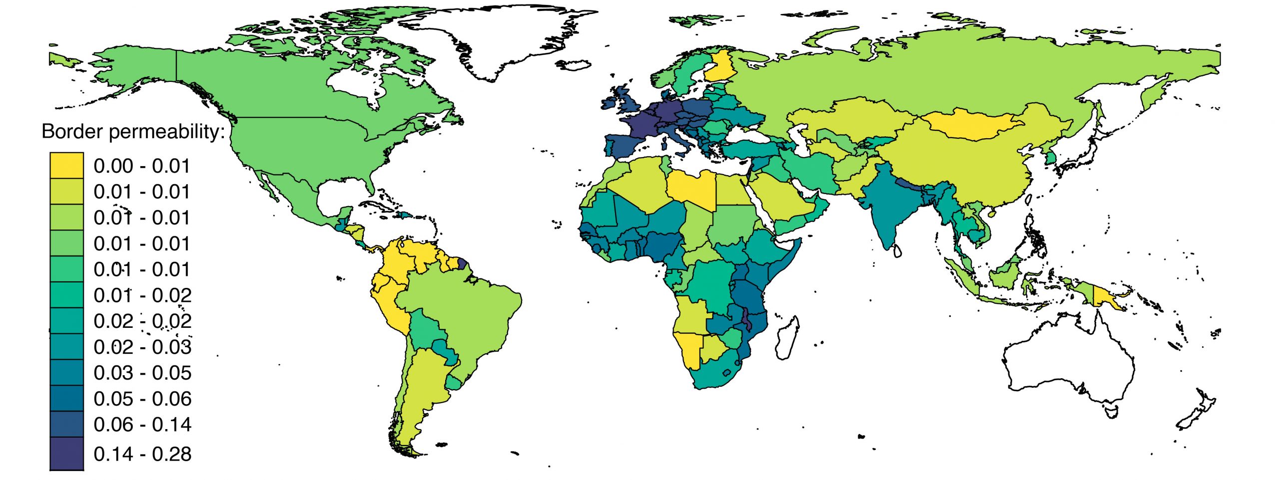
Mapping the results revealed that Europe and parts of Africa have the most, and the Americas the least, permeable borders worldwide (see Figure 2). This pattern holds independent of the degree to which checkpoints are used to shut down traffic infrastructure. The top 20 most permeable land borders are primarily located in Europe and often involve one small partner with Spain-Andorra, Slovenia-Austria, and Luxembourg-France constituting the top three. The Malawi-Zambia and Malawi-Mozambique borders are among the intra-African borders that appear among the 20 most permeable borders worldwide.
The least permeable borders tend to be in areas with low human settlement density and many natural obstacles to transport and mobility, such as rainforest (e.g., Venezuela-Guyana, Democratic Republic of the Congo-Central African Republic, Suriname-Brazil, Papua New Guinea-Indonesia) and deserts/arid land (Sudan-Libya, Iraq-Jordan, Saudi Arabia-Kuwait).
Figure 2. National averages of border permeability
Source: Deutschmann et al. 2023
The U-shaped relation between economic development and border permeability
Interestingly, political and cultural relations between neighboring countries have little impact on the permeability of their border in terms of traffic infrastructure. Just two factors really matter: the presence of humans (measured via settlement and population density in borderland areas as well as cross-border trips) and economic development.
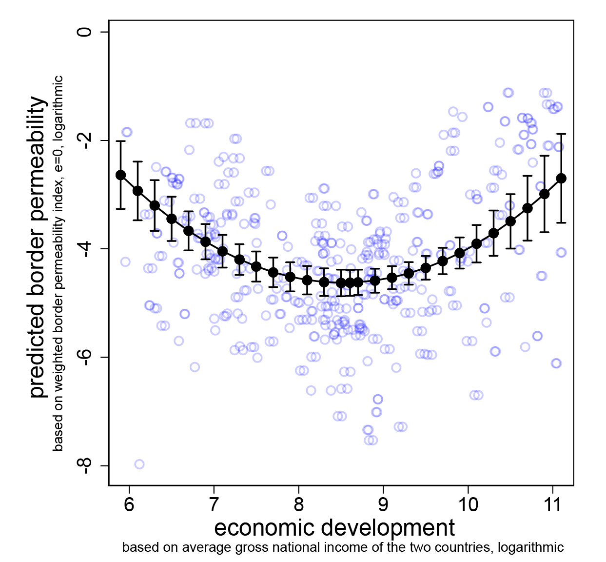
Economic development is by far the most important explanatory factor and has a U-shaped relationship with border permeability (Figure 3). Borders of rich and poor country pairs are highly permeable, whereas those of moderately prosperous nation states are significantly harder to cross. What could explain this remarkably clear pattern?
- High-income countries: For high-income countries, high border permeability is unsurprising given their abundant resources to build transport infrastructure and their economies that are often based on free trade and open markets. Furthermore, free movement becomes an important social value as societies grow rich and postmaterialist.
- Low-income countries: A possible explanation for the high permeability of borders between low-income countries is their origin as artificial colonial constructs. Drawn by colonial powers, these border lines cut across the geographies of socially meaningful ethnic communities where frequent mobility and exchange existed long before these borders were invented. Moreover, countries with limited resources still have low state capacity today and thus do not have the same effective power to control the outskirts of their territories.
- Middle-income countries: Middle-income country pairs find themselves in a different position. They have fewer resources to build transport infrastructure than rich countries. At the same time, however, their state capacity is higher than in poor countries, thus providing more control over territory. Combined intermediate prosperity can also occur when a rich state borders a poor state. In these cases, there are additional reasons for lower permeability, including the richer state’s interest in reducing the influx of migrants and in avoiding tax losses due to cross-border consumption.
Figure 3. The U-shaped relationship between economic development and border permeability
Source: Deutschmann et al. 2023
Border permeability: why we need to understand it & how to do it
Understanding border permeability could provide several important insights, including:
- predicting and explaining human mobility and trade
- better understanding development, security, peace and conflict, and
- exploring the connectedness of border permeability with state authority, nationalism and nation building.
Our new, publicly available global dataset on border permeability enables this analysis.
Learn more:
- Download the Border Permeability Dataset
- Read the original research article:
Deutschmann, E., L. Gabrielli & E. Recchi. Roads, Rails, and Checkpoints: Assessing the Permeability of Nation-State Borders Worldwide. World Development 164: 106175. https://doi.org/10.1016/j.worlddev.2022.106175 - With questions: Email emanuel.deutschmann@uni-flensburg.de


